Tualatin River Diaries, Days 4 & 5
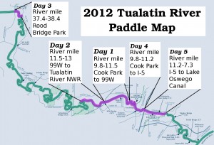
by Steve, November 6th, 2012River Mile 7.3 – 11.2
We just hung up the canoe for the season, a couple wishful weeks after our last weekend of good paddling weather. Our final days took us back to Tigard’s Cook Park, the same as day 1.
This time we headed downstream to the I-5 bridge. With the exception of one shallow section with some rocks to navigate (river mile 9.3, see map), this was the most unobstructed section of the Tualatin we had yet paddled.
The next day, we put in at the Rivergrove boat ramp (river mile 7.4), and paddled back up to the I-5 bridge. Heading back, we decided to continue downstream on a broadest, straightest, most unobstructed stretch of the river we paddled, to the Lake Oswego Canal (just west of Wanker’s Corner, where we’ll start next srping).
Note to future self: This stretch of the river was our favorite so far. (But we’ve still got several miles to explore!)


November 6th, 2012 at 5:16 pm
Ha! Wanker’s Corner. Hahahahaha!