Tualatin River Diaries, Day 2
by Steve, July 29th, 2012River Mile 11.5 – 13
Day 2, and we picked up where we left off yesterday: River mile 11.5, where OR Highway 99W crosses the Tualatin River on the south side of Tigard.
We paddled upstream to the edge of the Tualatin River National Wildlife Refuge.
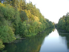
The Tualatin River is flows mainly through farm land, but there is some exurban development and a little river-front property. The 4.2 miles we’ve paddled so far is predominately wooded, pretty much like the picture above (not sure exactly where this one was taken).
River travel gives an uncommon view into a world filled not only with all kinds of wildlife and trees and shrubs draped over placid waters, but derelict irrigation pumps, makeshift riprap, wrecked and working docs, decks and gazebos perched high on the river banks, precarious stairways and ladders to the water, and not as much trash as you might expect (thanks in no small part to the efforts of the Tualatin River Keepers).
Our only wildlife close encounter today was an adolescent female mallard, swimming on a collision course with us from 12 o’clock. We stopped paddling, but she kept at us, only veering away at the last minute, intent on her hunt. And a couple of buzzards, who apparently don’t have as much confidence in our seamanship as we do; they always seem to be around when we’re out.
So not as much wildlife today as yesterday, but we did see some colorful human denizens in the water cleaning up a fallen tree to the dulcet tones of Green Day.
Next up: put in at Shamburg Bridge (River mile 16.2) and go downstream to where we left off today.


